Did Iran Destroy US’s $1.1-Billion Ballistic Radar At Qatar Base? Satellite Images Confirm Damage
Curated By :
Last Updated:March 04, 2026, 12:22 IST
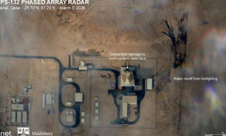
Satellite imagery from Planet Labs shows scorched ground and signs of firefighting. This radar is one of only six in the world and provides critical long-range tracking for the US
resetRapid ReadRapid ReadSummarized by AI.+Satellite images show US radar in Qatar damaged by Iran strikeThe $1.1B radar is one of only six in the worldDamage may reduce US missile defense reaction time in the Gulf More Rapid Read Like this summary?Share Your Feedback
Did Iran’s one-way attack drone or other projectile, significantly damage the U.S. Space Force’s AN/FPS-132 (Block 5) Ballistic Missile Early Warning Radar System in Qatar, which is worth roughly $1.1 billion and is the largest radar operated by the United States in the Middle East?
Satellite imagery from Planet Labs has now confirmed the damage.
Recommended Stories
- Iran To Israel In 12 Minutes? The Trajectory And Power Of Ballistic Missiles Explained
- Iran's Participation In FIFA World Cup 2026 Uncertain Amid Ongoing Military Conflict
- Israel-Iran War: Whose Military Has The Upper Hand?
- Will Trump Attack Iran During Ramadan?
Around 200 compliant tankers stranded as Strait of Hormuz closure freezes Gulf trafficIran insists it has ‘complete control’ of Strait of Hormuz@ShivaniGupta_5 Explains which countries will be impacted and how? #StraitOfHormuz #Israel #Iran #Oil pic.twitter.com/SLXhlZLpNo
— News18 (@CNNnews18) March 4, 2026
Iran’s strike and damage
The strike occurred around Saturday. The radar installation is located near Al-Khor (north of Al Udeid Air Base) in Qatar.
ALSO READ | Iran Strikes Amazon Web Services: Data Centres Are New ‘Oil Fields’? Modern Warfare, Targets Explained
While the Islamic Revolutionary Guard Corps (IRGC) claimed a “precision missile strike," other reports and open-source analysts suggested a low-cost one-way attack drone (potentially a Shahed variant) may have penetrated defenses during a saturated barrage of missiles and UAVs.
What does satellite imagery show?
Satellite imagery from Planet Labs reportedly shows scorched ground, debris, and signs of firefighting at the site.
The attack was part of Operation “True Promise 4," which Tehran described as retaliation for joint U.S.-Israeli strikes on Iranian military and nuclear facilities. Other reported targets in this wave included the U.S. Fifth Fleet headquarters.
Satellite imagery from Planet Labs has now confirmed claims made by a number of Iranian-affiliated channels over the last few days, that an Iranian one-way attack drone, or other projectile, was able to successful impact and significantly damage the U.S. Space Force’s AN/FPS-132… pic.twitter.com/9w2OmMMEex— OSINTdefender (@sentdefender) March 4, 2026
How the radar helps strategically
The AN/FPS-132 (Block 5) is a highly advanced, $1.1 billion Upgraded Early Warning Radar (UEWR) that serves as a cornerstone for long-range missile defense in the Middle East. This radar is one of only six in the world and provides critical long-range tracking for the U.S. and allies, supporting systems like THAAD and Patriot. Its loss reportedly reduces U.S. Central Command’s (CENTCOM) sensor depth, compressing reaction timelines for missile defense across the Persian Gulf.
The system has an operational range of approximately 5,000 km, allowing it to detect and track ballistic missiles shortly after launch from deep within foreign territory. Unlike older versions, the Block 5 in Qatar features three electronically steered phased-array faces, providing a full 360-degree surveillance azimuth.
It operates in the UHF band and is designed to continuously track ballistic missiles and space objects. It generates high-fidelity trajectory data, impact predictions, and cueing information for interceptor systems like THAAD and Patriot.
Beyond missile warning, it supports the Space Surveillance Network (SSN) by tracking newly launched satellites and orbiting space debris.
Backbone of regional missile defence: Why it matters
Military analysts describe this radar as the “backbone" or the “kill chain anchor" of the regional missile defence architecture. It is not a tactical point-defense sensor but a strategic-level tracker that builds the initial engagement picture.
Its primary role is to provide “early warning". Targeting the sensor layer is a tactical choice intended to reduce the reaction window for U.S. and allied forces, making it harder to intercept subsequent waves of high-speed missiles.
Positioned near Al-Khor in northern Qatar, it complements the massive Al Udeid Air Base, which serves as the central hub for U.S. Central Command (CENTCOM) operations.
With Agency inputs
tags :news18 specialsus iran warClick here to add News18 as your preferred news source on Google. Check Iran Israel War News Live, Dubai News Today And Lunar Eclipse 2026 In India Updates.
Stay updated with the latest news updates along with key india news and world news. Explore viral news, politics, city news, explainers, and expert opinions on News18. Join the fun, play games on News18. Download the News18 App to stay updated!view commentsLocation : New Delhi, India, IndiaFirst Published:March 04, 2026, 12:01 ISTNews world Did Iran Destroy US’s $1.1-Billion Ballistic Radar At Qatar Base? Satellite Images Confirm DamageDisclaimer: Comments reflect users’ views, not News18’s. Please keep discussions respectful and constructive. Abusive, defamatory, or illegal comments will be removed. News18 may disable any comment at its discretion. By posting, you agree to our Terms of Use and Privacy Policy.Loading comments…Read More